Madison Square

Madison Square
Savannah Under Fire archaeologists work in Madison Square, Savannah, GA, surrounded by visitors and citizens interested in our dig.

Monday, July 26, 2010

Mystery ceramics

I have a mystery for the ceramic experts out there!

On several archaeology sites in downtown Savannah (within the bounds of the battlefield) I have a found a mysterious decoration on several ceramics. It appears to be hand painted purple. One shade of the purple is flat, the other is metallic/iridescent.

In the first example I found, the design appeared to be painted on whiteware. Unfortunately, this sherd has been sent into deep storage, and I don't have any pictures of it. The three sherds pictured below were found in the 1980s and labeled "lustrous manganese creamware" or "lustrous manganese pearlware". This decoration style has appeared on porcelain and white earthenware. The earthenware has yellow or blue tints to the glaze, or the glaze is completely white.

Can anyone identify this more specifically than "handpainted"?  Does anyone have a time frame or TPQ for this type of decoration?
Many thanks!

Sherd 1- refined earthenware. white glaze has a blue tint.


Sherd 1, showing metallic purple


back of Sherd 1


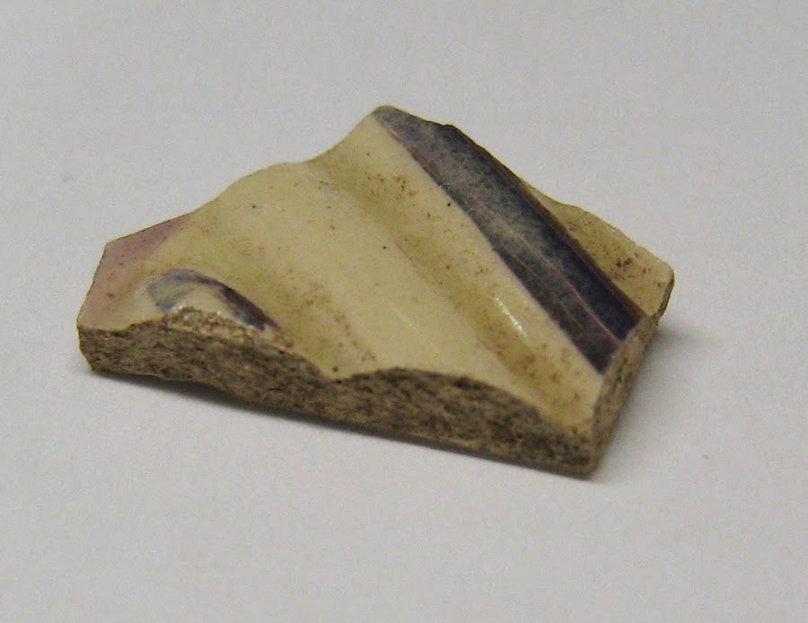
Sherd 2- refined earthenware. glaze is yellow-ish. Note there are two shades of purple present.

Sherd 3- porcelain. hand painted glaze is two shades of purple: the lighter, flat color and the darker, metallic color


Sherd 3 side view

Sherd 3

Wednesday, June 23, 2010

Updating the Stiletto

We received a response to our inquiry into the Pulaski Stiletto. Angus Patterson, Curator of European Base Metals and Arms and Armour at the Victoria & Albert Museum in England, kindly called it a "slightly bizarre object." Mr. Patterson said the hilt was unusual, although the blade and tang were standard. As to the inscription, it is consistent with late 1700s/early 1800s monograms on silver.

So we learned the stiletto could date to the Revolutionary War, but still no more evidence that it was Casimir Pulaski's. Mr. Patterson also suggested another expert to ask, so stay tuned for another update. Thanks to Mr. Patterson for his help.


Tuesday, June 15, 2010

more secrets in bones

Out to unearth skull’s secrets ajc.com

Discovered this article on a cool blog, the Anthropologist in the Attic. Before the mystery of Casimir Pulaski's bones, there was a Spainish friar whose skull may have been found at Fort King George State Park in Darien more than 50 years ago.

Wednesday, June 9, 2010

Pointy Stilettos

The Coastal Heritage Society recently received a very generous donation. The descendants of Revolutionary War soldier Richard Clough Anderson gave us a small knife, called a stiletto, that is attributed to Casimir Pulaski. Family oral and written histories indicate that a dying Pulaski gave a wounded Anderson his sword (and possibly the stiletto) as they were transported away from the Battle of Savannah.


Pulaski's stiletto?

Richard Clough Anderson fought for independence from January 1776 until the end of the war, serving in several Virginia Regiments. Throughout his six years of service, he was promoted from Captain to Major to Lt. Colonel. According to his pension records, he was in the battles of White Plains and Trenton (1776); Princeton, Brandywine, and Germantown (1777); Monmouth (1778); the Siege of Savannah (1779); the Siege of Charleston (1780) after which he was imprisoned for nine months; and Gloucester and Yorktown (1781). He was wounded once by a lead ball in New Jersey, and a second time by a sabre during the Battle of Savannah. These facts can be established from his pension record (http://www.footnote.com/).

Anderson family histories record even more colorful details. While Anderson was in the hospital with his first wound, he contracted small pox. "Never having any great beauty to spare, on his recovery from this attack, he came out of the hospital with the reputation of being one of the three ugliest men in the American army" (Anderson 1908: 9). He is also reported to be one of the first to surmount Spring Hill Redoubt before being stabbed in the shoulder by Captain Tawes (or Towles) and falling to the base of the trench (Anderson 1908: 10, Anderson 1879:25).

We are in the process of trying to authenticate the stiletto and its oral history. One clue is the engraved letters on each side. The script is beautiful and intricate- but what are the letters?!?  Some staff members have seen "A P." Others see "C P."


Anderson's pension record also indicates he had a son, William M. Anderson. I see "WMA" in the photograph above. What letters do you see?

More historical research will also be necessary to document the relationship between Casimir Pulaski and Anderson. Finally, we are looking at the materials and manufacture of the knife itself. Is this stiletto typical of the late 1700s? Are there modern tool marks? Were the letters engraved when the knife was made or were they added later? Only an antique metals expert will be able to determine the answer to these questions.

If anyone has insight into this mystery, please email us at curatorial@chsgeorgia.org.


References Cited:
Anderson, Charles
1908     Ye Andersons of Virginia and some of their descendants.
Anderson, E.L.
1879     Soldier and Pioneer: A Biographical Sketch of Lt. Col. Richard C. Anderson of the Continental Army. G.P. Putnam's Sons, New York.

Monday, May 31, 2010

Before GI's: Original American Soldiers

As I work on Memorial Day, I was thinking about our original American soldiers and sailors who fought in the American Revolution.  My favorite being George Washington. But he gets enough press.

I would like to celebrate the soldiers who slogged through the mud but didn't get recognition. Men like Eleazar Phillips, who after being discharged from the militia in Charleston, served aboard the Wasp as a Steward and Purser under Capt. Bulfinch. Historical documents indicate he was present for the death Casimir Pulaski aboard the Wasp after the 1779 Battle of Savannah.  After being honorably discharged again, Phillips joined another militia company, serving in the Siege of Charleston. In May of 1780, he was taken prisoner for 12 months.

Phillips served for low, frequently late, pay with no promise of a pension or GI Bill. If the rebels lost.... Well, Ben Franklin said it best at the signing of the Declaration of Independence, "We must all hang together, or assuredly we shall all hang separately."

The pages below are Martha Phillips' 1838 deposition, part of her application for her husband's pension.
Source: footnote.com


Before 1818, pensions were only awarded to officers or those killed or disabled. (Widows could apply for the pensions of deceased servicemen.) The Revolutionary War pensions records are available on footnote.com. These records, mostly from the National Archives, have been scanned and are searchable. Some records are available free of charge, or you can subscribe to have access to all of the records.

I highly recommend browsing through their stash. While old documents can be difficult to read, the software makes it as easy as possible.  The stories of the servicemen vibrantly come through the documents. And footnote has documents throughout the entire span on American history, so don't stop at the Revolution!

Monday, May 24, 2010

scrubbing without bubbles

I have not posted recently because I have been washing and rebagging artifacts. There isn't much to say about scrubbing tiny bits of ceramics and brick with a toothbrush. Do check out my (mildly) humorous video, "The Dungeon", about the process though.

But while this is not the most exciting part of doing archaeology, it is important. Washing away the dirt allows me to see the details of the object. Doing a preliminary sort while rebagging the clean artifacts makes analyzing the artifacts much easier. Also, I put the cleaned artifacts in special archivally-sound plastic bags. These bags do not give off nasty petrochemicals over time, like ordinary grocery store zip-locks do. These bags are part of how we keep the artifacts safe and preserved for generations, ensuring that future archaeologists will be able to restudy the artifacts. Remember, once an archaeological site is dug, it is gone forever. It is the archaeologists duty to preserve all of the artifacts, field records, maps, photographs, etc... so that the site can be restudied by future archaeologists with better technology. Or the data can be used to compare several similar sites to learn about the bigger picture of human behavior and cultures.

In other news, The Civil War Preservation Trust has announced the 2010 Most Endangered Civil War Battlefields, including Pickett's Mill Battlefield State Historic Site in Georgia. Check out their cool interactive map.  Or get involved through donation, becoming a member, or speaking out.

Thursday, May 6, 2010

Metal detecting archaeologists

After the disastrous defeat in 1779, the allies fled past two (still present) Jewish Cemeteries where a regiment of Haitian volunteers protected the retreating soldiers. Earlier in the year, we did ground penetrating radar and shovel test pits over several acres of private property around the cemeteries. These property owners generously allowed us to harass them a second time, as we conducted a metal detector survey last week. The results of our survey can be found on the YouTube video, "The Retreat". There is also a two-part interview with Dan Battle, an archaeologist and our metal detector expert/consultant.


I have previously written about our difficulty in finding sites this fieldwork season. I have asked if any citizens out there have found Revolutionary War items in their backyards. (Email photos to curatorial@chsgeorgia.org). No one has responded. So we turned to the people who have found artifacts: the metal detector hobbyists.

Even being in the same room as "evil metal detecting looters" would send some archaeologists running for the hills. I would like to propose a more moderate, central position for both archaeologists and metal detectorists. First, there are many different attitudes among metal detectorists ranging from people who loot and sell artifacts for money to those who only collect on sites about to destroyed by development. Selling artifacts for profit is completely unethical for the professional archaeologist (see the Society for American Archaeology Principles of Archaeological Ethics). 

But what about sites that were destroyed and no archaeology was conducted? What if we could recover some information from a metal detectorists who hunted part of the 1779 Battle of Savannah retreat during a construction project? What if that information could be used to find more of the site and ultimately led to more site preservation?

Perhaps metal detectorists and archaeologists could work together on projects where archaeologists supply the methodology and scientific rigor, and detectorists supply the manpower and expertise with their machines. This has been wildly successful on the BRAVO project (Battlefield Restoration & Archaeological Volunteer Organization) which focuses on the Revolutionary War Battle of Monmouth in Freehold, NJ.  Dan Sivilich gave an excellent presentation at our 2010 Society for Historical Archaeology conference symposium, Revolutionary Steps: Marching Towards Research and Preservation. His notes are posted on our slideshare site.

Savannah is losing archaeological sites at an alarming, rapid rate. We all care about Savannah's history; let's work together to preserve and protect it. Archaeologists will have to admit that metal detectorists are more knowledgeable in certain areas. Metal detectorists will have to exchange learning new information for keeping bags of useless artifacts. (useless, of course, because they have been pulled out of the context). I think we can find a détente where we can save the last of the Revolution in Savannah.

Disagree with me? Fire away in the comments section.

Tuesday, April 27, 2010

Drinking the YouTube KoolAid

I finally caved and created a YouTube page for Savannah Under Fire, because I have a video and I want to spread the Savannah Under Fire love. You can see us working in Davant Park in this 4 minute video.

Find our YouTube page here. Know it, love it, watch it.

Monday, April 19, 2010

One musket ball, two musket balls?

We found a musket ball in Davant Park today!  Unfortunately, it was in a soil layer that was disturbed and mixed up. So it can't tell us anything about the Revolution. Visit us tommorow (Tuesday) at Davant Park to see if we've gotten deep enough to find the Revolutionary War soils layers.

Friday, April 16, 2010

Fieldwork Recommencement

We'll be kicking off two more weeks of fieldwork on Monday (April 19th). We will be returning to Davant Park, the area south of Colonial Cemetery where Lincoln St. dead ends into Perry Ln.

We are very excited about this location. Our historic maps indicate that ditchwork connecting two redoubts probably runs through this area. In October 2008, we did ground penetrating radar (GPR) in the southeast quadrant of Colonial Park Cemetery and in Davant Park. Our GPR guru Dan found a large, linear anomaly running northeast/southwest throughout this area. This means that there is some natural or cultural ditch running through this area. Monday we will be digging some test units (1 by 2 meter squares) to see if this ditch is really from the American Revolution.

This is a GPR image of Davant Park. North is up. Each tick mark is one meter. 
(Figure 122 from our technical report)

Another advantage of doing GPR before digging is that we are able to "see" graves. Dan mapped numerous unmarked graves within the walls of the cemetery. Unmarked graves are very common in old graveyards, and the graves frequently extend beyond the marked edges of the cemetery. But surprisingly, there were no graves south of the Colonial Cemetery's brick wall.

Stop by and we'll give you a tour!

Thursday, April 15, 2010

Visit Camp Lawton this weekend

This is a great opportunity to visit a cool archaeology site near Savannah. Two of Savannah Under Fire's own have worked on this project: Dan Elliott and Matt Luke. (hi guys!) The Camp Lawton dig is at Magnolia Springsa State Park. You can visit the dig on April 17 and May 1. Other dates will be posted on www.gastateparks.org/MagSpr or call 478-982-1660.


I'm passing along the article below (verbatim) from the Georgia Preservation Online newsletter.


Archaeological investigations have begun at Camp Lawton in Magnolia Springs State Park near Millen, Georgia. The excavations are the result of a partnership between the Georgia Department of Natural Resources (DNR) and Georgia Southern University.


Camp Lawton was established during the Civil War in the fall of 1864 by the Confederate Army to house Union prisoners of war at Magnolia Springs in order to take advantage of the abundant water supply. Built by slave labor of pine timber harvested on site, the walls measured 12 to 15 feet high. The stockade began receiving the first of at least 10,299 prisoners in early October. The post was abandoned by the end of November when threatened by Sherman’s drive on Savannah. The prisoners were transported to other, safer, locations. On December 3, 1864 Sherman’s forces took possession of Millen and Camp Lawton. The depot (and likely the stockade and all support structures) was burned by his men.

Ground penetrating radar (GPR) conducted in December 2009 by the Lamar Institute revealed a possible location for the southwest corner of the prison stockade. Georgia Southern University has begun archaeological investigations to “ground truth” the results of the GPR survey. State archaeologist and Historic Preservation Division director Dave Crass said, “The results of the survey and testing will aid DNR in interpretation and future investigations at the Park.”

The public is invited to view the progress of the excavations at the park on April 17 and May 1. Other dates will be posted on www.gastateparks.org/MagSpr or call 478-982-1660.

Tuesday, April 13, 2010

Shout Out to Prof. Bruno's Intro to Anthropology Class!

Who is up to speed on Revolutionary War Savannah? Who has a handle on archaeological discoveries in Savannah? The answers are the same...Professor Barbara Bruno's Introduction to Anthropology class at Armstrong Atlantic State University (AASU)! Thanks to all 40 or so students who came to class prepared, interested, and ready to engage in a discussion about the Savannah Under Fire project. It was fun (for me, anyway!) I look forward to reading your papers and know that they will help us hone our public outreach. Thank you! Please visit us on-site if you get a chance. We'll be starting on April 19 at Davant Park. That is the strip of greenspace between East Perry Lane and the south wall of the Colonial Park cemetery. Look for our archaeology banner. Come by between 9-5 on April 19 (Monday) or April 20 (Tuesday). After that, depending on what discoveries we make, we will be at various venues around town. Check out this blog as we continue to update the schedule throughout the next two weeks. If you visit, make sure you remind me you are in Prof. Bruno's class. Hope to see you. Meanwhile, good luck with your classes!

Friday, April 2, 2010

Archaeology Talk Talk Talk

UGA professor Erv Garrison will be speaking about his excavation at the Grove’s Creek site on April 6 at 6:30 p.m. at St. Paul’s Episcopal Church (1802 Abercorn St.). Get the details in Connect Savannah's article. This talk is part of the annual lecture series presented by the SCAD Architectural History Department. I have visited this amazing site and can't wait to hear Dr. Garrison's update.

Make sure you read the article all the way through- the end talks about our latest work at the Roundhouse Railroad Museum.

Monday, March 29, 2010

Archaeology Education & Glynn County

The Glynn County School System has an amazing, dynamic Archaeology Education Program in which students learn the required state quality core curriculum objectives through archaeology and hands-on activities. The county is thinking about eliminating this program because of budget shortages.

Please support this fabulous program by:

1- becoming their fan on Facebook and leaving your comments in support of the program.

2-  or more importantly, write to the superintendent and tell him you support innovative educational programs like this one.

3- also, write to the Board of Education and let them know special programs like this are important.

Sunday, March 21, 2010

Help!

You may recall that in a previous post I discussed our minimal success in finding archaeology sites from the 1700s. We spent much of our first three weeks of fieldwork focused on finding where the American and French armies camped during the Siege of Savannah. We have maps showing the approximate locations, but no solid leads yet.

Map of the 1779 Siege of Savannah, from the Coastal Heritage Society Collection.


Finding the soldiers' camps is difficult for several reasons.

1- Our method of locating sites is georeferencing historic maps in GIS. Translation: I use a computer program called ArcMap to match up historic maps with a modern map of Savannah. However, when we line up the maps, our matching points are all located downtown. So as the historic maps is stretched and resized the edges can become distorted and somewhat inaccurate. This is why we were so successful finding sites downtown, but have had much less luck mid-town.
2- Historic maps simply are not as accurate as modern maps. We have looked at almost 30 historic maps and each varies. Some of the maps even conflict with each other.

3- The camps were only occupied for several weeks. The soldiers would probably have only lost or discarded a minimal number of artifacts.

4- As Savannah grew and more land was developed, the sites may have been destroyed or buried very deeply under lots of soil, making them hard to reach.

5- We have dug small pits called shovel tests in seven parks throughout mid-town Savannah looking for the camps with little success and without finding any military artifacts. This technique is limited in the area we can cover and the depths we can reach. Metal detectors are frequently used to find military sites because of the high percentage of buttons, bullets, and gun parts on military sites. But in modern Savannah, we have found that there is too much modern trash for this technique to work. We do find pennies and nickles though.


Therefore, we need your help to find these sites. Have you ever found any artifacts in your yard? Send us pictures of these artifacts and the address where they were found to curatorial@chsgeorgia.com. We would be happy to give you more information about the artifact if possible.

Monday, March 15, 2010

Mapping Our Treasures

Two important federal grant programs are on the fiscal chopping block. Eight of these projects are in Savannah, several of which are Coastal Heritage Society Projects. Please write to your Congressmen and Senators and tell them we care about America's Treasures!

Mapping Our Treasures- This map shows you where each Save America's Treasures and Preserve America site is located. Scroll over to see the many Georgia projects.

Georgia Trusts You

The Georgia Trust has a great new blog about preservation issues and preservation legislation in Georgia. Keep up to date on your community and find out how to take action to save Georgia's treasures. It's at the local level that we can all make a difference. Thanks for your support!

Tuesday, March 2, 2010

Savannah Under Fire?

I am frequently asked, why is the title of our project "Savannah Under Fire"? The answer is twofold. First, as the French and American Allies laid siege to British-held Savannah in the fall of 1779, the city was literally under fire. Mortars and cannons were fired into the city from the French fleet on the Savannah River and from batteries constructed south of the city. French and American troops also conducted sorties, attacking the British defenses surrounding the city.

Today, Savannah's archaeological sites are under fire from a less obvious source: development. It is a myth that archaeology holds up development. Once archaeology is properly integrated into the permitting process, it becomes simply another step in improving our city. Archaeology also has much to contribute to the culture of the city, just as the historic preservation movement has done wonders for Savannah.


Bull Street, just south of Broughton Street. Picture taken on 21 Feb 2010.

Close-up of the hole in Bull Street, note the brickwork.
Was an archaeological site destroyed here? I don't know. No one was allowed (or required) to check or document the area before work began. Unlike our beautiful live oaks, we cannot simply grow another archaeological site. Once it is destroyed, it is gone forever. Savannah still has archaeological sites long buried and waiting to share their history. Let's not squander them.

For more detailed information on the rate of destruction and the great potential of archaeology, please read the 7-page final chapter of our 2008 report on the first "Savannah Under Fire" grant available here, under documents.

Tuesday, February 23, 2010

Voluntold

Last week, we wrapped the first half of our fieldwork. In the next few weeks, we'll be analyzing artifacts, reevaluating maps, and creating a game plan for the second round of fieldwork. We'll also be doing some fieldwork at the Roundhouse Railroad Museum

A huge thanks to our wonderful volunteers who froze alongside us these past three weeks!

Ijtihad Muhammad


Matt Luke


Carl Arndt

Momoco Holder


Laura Lewis

Dawn Chapman Guest

Michael Lamb

Thursday, February 18, 2010

Finally? Maybe.

You may have noticed that I have been talking a lot about where we are digging, but not much about what we are finding. We have been discovering artifacts and archaeological sites throughout these past few weeks, but nothing older than the early 1800s. We simply haven’t found anything significant enough to report. Until now.


Today we dug shovel tests throughout Thomas Park, the park adjacent to Bull Street Library. In one corner of the park, we found artifacts that date to the colonial era, including Rhenish stoneware and tabby mortar (but still no military artifacts).

Tomorrow, Dan will run his ground-penetrating radar machine over the area. In addition to archaeological features, we will be looking for modern utilities. The park has a sculpture fountain, a drinking fountain, lampposts, and irrigation lines that have been dug into the archaeology site. We want to avoid these utilities for three reasons: we don’t want to break any of them, we don’t want to electrocute ourselves, and the utility has already destroyed the archaeology site so there is no point in digging near them.

When we being our second round of fieldwork in the spring, we will return to Thomas Park and dig larger areas to determine if there is intact soil from the 1700s.

Also tomorrow, catch us at WW Law Park digging more shovel test pits.

How we dig shovel tests:

 1. Dig a hole and screen the dirt for artifacts.


2. Measure the soil layers.


3. Write notes about the soils and artifacts found.


4. Fill hole back in.

5. Repeat.

Wednesday, February 17, 2010

Butterflies in the sky...

Thursday we will be digging in the park adjacent to Bull Street Library, one of my favorite places. Props to the Georgia Room and Interlibrary Loan departments- ya'll are awesome!

Tuesday, February 16, 2010

Tomorrow we will continue our relentless pursuit of the American Camps in Laurel Grove Cemetery. Thanks to Mr. Flowers and an anonymous tipster, we now know about some high ground nearby that might be an old road. Time to bring out the topo maps!


Laurel Grove is often overshadowed by its big sister, Bonaventure Cemetery. While boasting fewer famous people, and containing an overload of obelisks, Laurel Grove is still worth checking out.


Sunday, February 14, 2010

Presidents Day before we had presidents

Monday we will be working in Laurel Grove Cemetery.  Take advantage of the holiday to celebrate George and the Revolution!

Thursday, February 11, 2010

A Dirty Job

Why has Mike Rowe never done a Dirty Jobs show on archaeology? Archaeology is all about dirt. Everybody thinks it is all about the artifacts. They're important, but the dirt is the real information. The different colors, shapes, and textures of soil tell us if we are digging a privy, a modern pipe trench, or a post hole that was the corner of a house.

The difference between an archaeologist and someone digging to find artifacts (may I say looter?) are these clues from the differences in dirt. Archaeologists record the soils and the artifacts we find in each soil. We take pictures, fill out forms, map our finds, and write endless notes. In the lab, we use these field records and our artifact analysis to “reconstruct” the site and to understand the site. We then write our technical report and a (hopefully) more interesting public report.

Once you disturb the dirt by digging through it, you destroy history by destroying the dirt clues. Archaeology is a dirty job, in fact, we are dirt connoisseurs.

On Friday- catch us in Laurel Grove Cemetery.

Wednesday, February 10, 2010

whitfield/whitefield

Come to Whitfield Square tommorow and visit our hard working volunteers

and watch us dig small holes.

Tuesday, February 9, 2010

Calhoun who?

We started the week working on private property, but Wednesday we start in Calhoun Square. Everyone is welcome to stop by and learn about the project first hand. We will start by running the ground penetrating radar machine and digging shovel test pits. This square might be the location of French saps, or trenches. Our French allies were digging towards the British fortifications, hoping to weaken British defenses and end the siege.

Monday, February 8, 2010

René Descartes

The very first step in exploring a new archaeology site is setting up the grid. Remember the x,y coordinate system from elementary school? In high school the teachers called it the Cartesian coordinate plane. We superimpose one of these imaginary grids over the archaeology site so we can map all of our finds.
Rita sets up the transit.

We start by setting up the laser transit at our (0,0) location, or the datum. We use a grid north rather than true magnetic north. Our grid north is aligned with the town plan of Savannah. So as you drive towards the Savannah River on Bull Street, you are following our grid north. We use the transit to identify the location of more points along the grid, putting large nails into the ground to mark important points. The transit shoots a laser towards the prism rod, and the laser bounces off of the prism back to the transit. From this, the transit computer calculates distances and angles, allowing us to precisely identify any point with our grid.


Laura holds the prism rod while Rita operates the transit.

We map in all of our excavations, ground penetrating radar areas, and special finds. We also use the transit to map significant locations such as roads, buildings, monuments, and other obstructions. At the end of the day, we go back to the office and download these points (or coordinates). I can use basic drafting programs to make simple maps, or I can put these coordinates into our GIS (Geographic Information Systems) database and make more complex maps. (I’ll be posting more on GIS in the future.)

On last Tuesday, we began setting up our grid near the corner of Fahm and Zubley streets in Savannah. We established the grid, and Dan ran his ground penetrating radar (GPR) machine over the grassy greenspace between apartment buildings. We believe this area is the location of one of the redoubts (mini forts) that surrounded Savannah in 1779. Once the data is collected, Dan will use a computer program to post-process the data, producing 2-D and 3-D images of what anomalies lie beneath the surface. The GPR images will suggest what archaeological resources are present. However, the only way to know for sure is to dig, looking for artifacts and old soils. This process is called “ground-truthing”. I’ll let you know when we have GPR results!

We took advantage of the rain on Friday and visited Luciana at the Savannah City Archives. She helped us find many maps of the project area. Even though the Archives does not have any Revolutionary War maps, later maps are also helpful. We have to understand everything that has happened in between the Rev War and today in order to understand the archaeology site itself. For example, maps showing the Civil War fortifications can help us eliminate areas to dig. Or if many buildings have been built and rebuilt in an area, there might be many feet of other cultural layers covering up the Revolutionary War layers.
Thanks Luciana!
 
Rita examines maps in the Savannah City Archives.

Monday, February 1, 2010

fieldwork schedule

The real fieldwork begins this week! We are planning to spend the next three weeks in the field. We will be posting our tenative schedule and dig locations as we know them. Come visit us the field to watch history being discovered.


Unless , of course, it rains. This seems very likely.
The Plan:
~Tuesday we will be doing ground-penetrating radar at the corner of Fahm and Zubley Sts. We are hoping to locate the remains of one of the redoubts, or mini forts, that surrounded Savannah during the 1779 battle.
~Wednesday through Friday we will be working on private land where the Reserve Corps of Haitian volunteers protected retreating allied American and French forces.

The Backup Plan:
~Tuesday will be flexible. Maybe we can do some prep work in the afternoon if it stops raining.
~Wednesday we will do ground-penetrating radar at the corner of Fahm and Zubley streets, hoping to locate the remains of one of the redoubts, or mini forts, that surrounded Savannah during the 1779 battle.
~Thursday and Friday we will be working on private land where the Reserve Corps of Haitian volunteers protected retreating allied American and French forces.

Fine print: Our schedule is always tenative, based on weather, our latest findings, and emergencies.

Wednesday, January 27, 2010

Windshield Survey

We officially started our fieldwork today with a windshield survey. This is only slightly less lazy than an armchair survey. We do a windshield survey by scouting our possible dig locations and assessing their potential. At each site, we look for modern disturbances such as utilities, trees, and landscaping and search for hints about the eighteenth century topography. We also look for areas of bare dirt, which we comb for artifacts that have eroded, such as in the picture below.


Sometimes we get extra lucky. Near one of the redoubts (mini forts) there was a gaping hole in West Boundary Street that allowed us to see the soil layers beneath the street. Normally, archaeologists cringe at gaping holes dug into archaeological sites. We decided to turn this into an archaeological advantage. By examining the soil layers and the artifacts within them, we were able to date the layers of soil. Two meters below the surface, the soil only dates to the mid-1800s. This tells us that in order to find the 1779 battle, we need to dig very deeply!! We concluded that ground penetrating radar would be the best tool on this site.


We were very pleased with the results of today because we saw lots of potential for intact archaeological sites. Within the next few weeks, we will begin to dig and use ground penetrating radar to explore these sites further.

Tuesday, January 19, 2010

“Revolutionary Steps: Marching Towards Discovery and Preservation”

On January 7, the Savannah Under Fire people hosted a symposium at the 2010 Society for Historical Archaeology Conference. The symposium, entitled “Revolutionary Steps: Marching Towards Discovery and Preservation”, was a smashing success. Unfortunately for the audience, it was standing room only at some points. Some of the papers and PowerPoint presentations are available at our Slideshare site. Not all of the papers are formally written, but presenters have included their notes to help you understand the slideshow. Below is a list of all papers presented.


"Archaeology at the Battle of Hobkirk's Hill"
Tariq Abdul Ghaffar
ARCHH
"Ebenezer and Sunbury: Revolutionary War Landscapes of Two Dead Towns in Georgia"
Daniel Thornton Elliott
The LAMAR Institute, Inc.

"Francis Marion, Archaeology, and Heritage Tourism: Archaeological Investigation of Francis Marion’s camp and Redoubt at Dunham’s Bluff, South Carolina"
Steven D. Smith
University of South Carolina

"Hear the Cannons Roar! 20 Years of Metal Detecting at a Revolutionary War Battle Site"
Dan Sivilich
BRAVO

"Hidden Vestiges: An approach to recognizing an 18th-century historic landscape within an urban environment"
Larry B James
University of West Florida

"Identification and Mitigation at the Bufords Massacre Battlefield (29 May 1780), Lancaster County, South Carolina."
Scott Butler
Brockington

"Meeting at Headquarters: Public archaeology at Valley Forge"
Joseph R. Blondino
Temple University

"Preservation and Public Archaeology at Carleton Island, NY"
Douglas J. Pippin
SUNY Oswego

"Recounting the Revolution: Captivating Imagination through Public Archaeology"
Carin Boone
Temple University

"Rediscovering the Backcountry Battle of Kettle Creek in Wilkes County, Georgia"
Daniel Edward Battle
Cypress Cultural Consultants

"The Lost Colonial Port of Sunbury, Georgia"
Christopher P. McCabe, Stephen D. Dilk
Georgia Department of Natural Resources

"The Third Battle of Savannah: An Archaeological Struggle for Identification, Preservation, and Interpretation"
Rita Elliott, Laura Seifert
Coastal Heritage Society

Discussants: Charles Baxley (Southern Campaigns of the American Revolution), Daniel Elliott (LAMAR Institute)